RacesAlps
Tor des Géants
Demand
5 out of 5
How much it asks
Worth
5 out of 5
Whether the ticket is worth it
Courmayeur, Aosta Valley, Italy
Scorecard · is it worth it?
A name that still means something after the expo lights go off.
The card
Tor des Géants is not a 100 miler with extra laps. Scoring it as if it were is how people get hurt in September in the Aosta. The TOR330 is about 330 kilometers and 24,000 meters of climb on the Alte Vie 1 and 2, Courmayeur to Courmayeur, 150 hours, no imposed stages. You decide when to sleep. That sentence is the demand. Demand is 5 because the format, the vert, the repeated high passes, and the week-long weather problem stack. There is no honest 3 or 4 available.
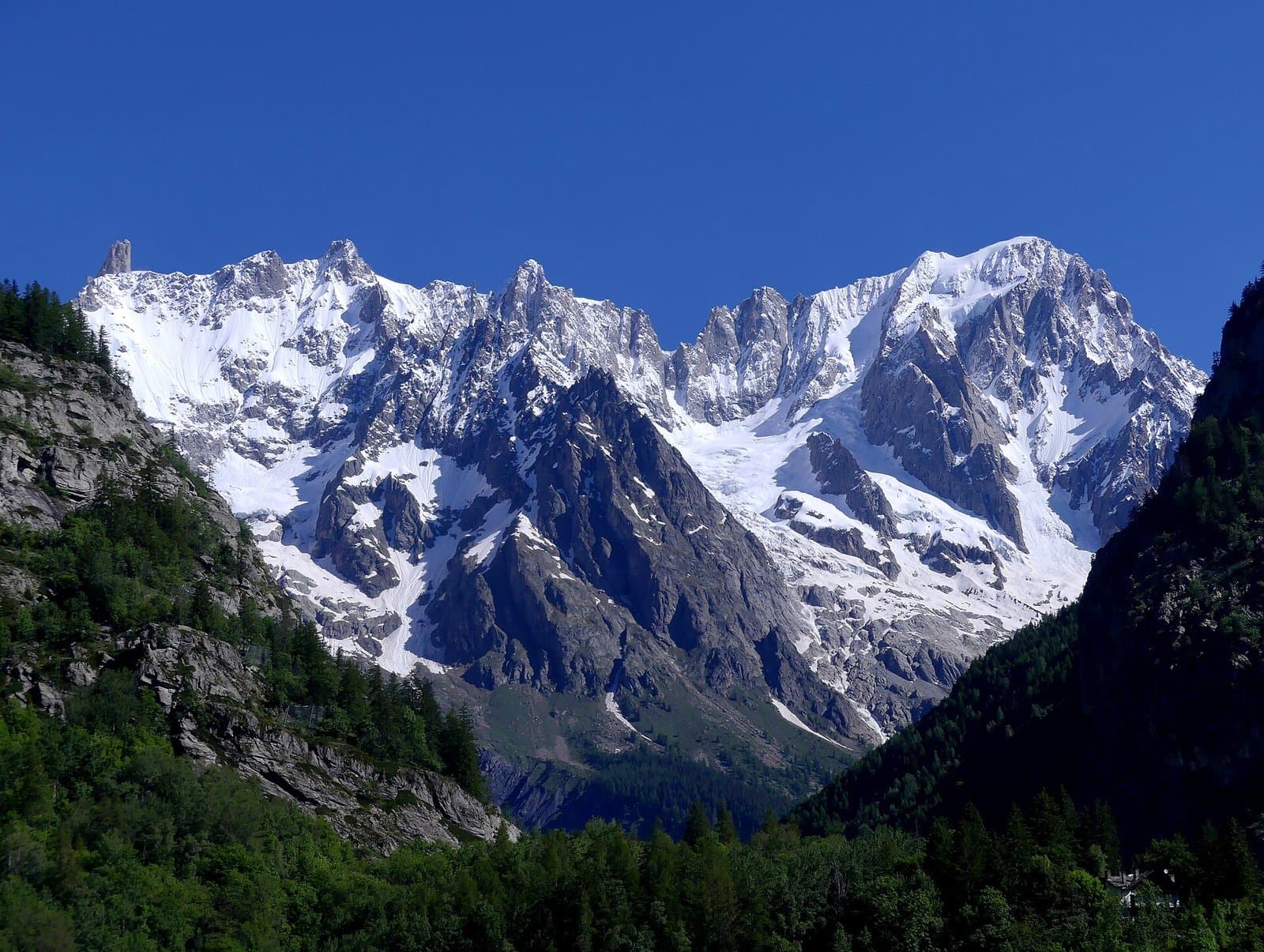
Worth is 5 for people who want this format. The Aosta high routes are a reason to fly: Mont Blanc at the start, Gran Paradiso, a chain of rifugi and life bases, villages that still understand mountain traffic. You are not buying a city expo with a mountain logo. You are buying a traverse that existed as a path system before it existed as a race. Value is a 4 because a week in Courmayeur in September is not cheap and the lottery is another gate. It is still a better purchase than a branded 100 on jeep roads.
Prestige is 5 inside the sport that cares about 200-plus. Organization is a 4 with high confidence: TORX is a large, documented machine, start waves, tracking, cutoffs, a finish deadline on Saturday evening. It is not a club. Technicality is a 4: alpine trail that becomes technical because you have been awake for two days, not because every kilometer is a scramble.
The people who DNF here often DNF on sleep and weather, not on a single climb. If your question is 'is this the mountain ultra to fly for,' the honest split is: yes, if you already belong in this sport; no, if you wanted UTMB with more kilometers. They are not the same weekend.
Who it is for
Runners who already understand 100 miles and want the next problem: a week on the Aosta high routes, self-managed sleep, and a 150-hour clock.
Who should skip
Anyone treating this as a long 100 miler. If you have not solved eating, sleep, and weather over two nights, do not buy a week.
Elevation
Tap or hover for miles, clock, and aidft
Dark from 19:48 to 07:07 local. No split grid; shading uses start time and clock only.
Bottom ticks are aid. Longest gap 10.1 mi.
Hardest stretch
Hardest stretch: Eaux Rousses to Col Loson, 4,942 ft in 7.7 mi.
Segment gains from the course elev profile.
| From | To | Mi | Gain | Loss |
|---|---|---|---|---|
| Start | Baite Youlaz | 8.012.9 km | 4,071 ft1,241 m | 1,454 ft443 m |
| Baite Youlaz | La Thuile | 3.86.1 km | 0 ft0 m | 1,832 ft558 m |
| La Thuile | Rifugio Deffeyes | 5.58.9 km | 3,356 ft1,023 m | 11 ft3 m |
| Rifugio Deffeyes | Bivacco Zappelli | 3.15 km | 1,227 ft374 m | 1,965 ft599 m |
| Bivacco Zappelli | Col de la Crosatie | 1.93.1 km | 2,194 ft669 m | 437 ft133 m |
| Col de la Crosatie | Planaval | 4.36.9 km | 33 ft10 m | 4,103 ft1,251 m |
| Planaval | Valgrisenche | 3.65.8 km | 591 ft180 m | 138 ft42 m |
| Valgrisenche | Rifugio Chalet de L'epée | 3.96.3 km | 2,222 ft677 m | 0 ft0 m |
| Rifugio Chalet de L'epée | Rhemes-Notre-Dame | 5.08 km | 1,357 ft414 m | 3,406 ft1,038 m |
| Rhemes-Notre-Dame | Col Entrelor | 3.35.3 km | 3,609 ft1,100 m | 0 ft0 m |
| Col Entrelor | Eaux Rousses | 6.210 km | 278 ft85 m | 4,091 ft1,247 m |
| Eaux Rousses | Col Loson | 7.712.4 km | 4,942 ft1,506 m | 0 ft0 m |
| Col Loson | Rifugio Vittorio Sella | 2.84.5 km | 136 ft41 m | 2,112 ft644 m |
| Rifugio Vittorio Sella | Cogne | 5.58.9 km | 0 ft0 m | 3,393 ft1,034 m |
| Cogne | Goilles Dessous | 3.65.8 km | 925 ft282 m | 3 ft1 m |
| Goilles Dessous | Rifugio Dondena | 10.116.3 km | 3,130 ft954 m | 2,026 ft618 m |
| Rifugio Dondena | Chardonney - Champorcher | 3.55.6 km | 0 ft0 m | 2,311 ft704 m |
| Chardonney - Champorcher | Pontboset | 4.87.7 km | 0 ft0 m | 2,223 ft678 m |
| Pontboset | Donnas | 6.510.5 km | 492 ft150 m | 2,045 ft623 m |
| Donnas | Perloz | 3.65.8 km | 1,301 ft397 m | 256 ft78 m |
| Perloz | La Sassa | 4.57.2 km | 2,976 ft907 m | 329 ft100 m |
| La Sassa | Rifugio Coda | 2.84.5 km | 2,522 ft769 m | 122 ft37 m |
| Rifugio Coda | Rifugio della Barma | 5.18.2 km | 1,121 ft342 m | 1,509 ft460 m |
| Rifugio della Barma | Lago Chiaro | 3.35.3 km | 1,094 ft333 m | 1,008 ft307 m |
| Lago Chiaro | Colle Della Vecchia | 2.54 km | 1,226 ft374 m | 909 ft277 m |
| Colle Della Vecchia | Niel - Dortoir La Gruba | 3.55.6 km | 290 ft88 m | 2,189 ft667 m |
| Niel - Dortoir La Gruba | Bleckene - Lòò Superiore | 3.86.1 km | 2,509 ft765 m | 953 ft290 m |
| Bleckene - Lòò Superiore | Gressoney | 4.57.2 km | 89 ft27 m | 2,378 ft725 m |
| Gressoney | Rifugio Alpenzu | 3.15 km | 1,209 ft369 m | 0 ft0 m |
| Rifugio Alpenzu | Champoluc | 7.411.9 km | 3,423 ft1,043 m | 3,982 ft1,214 m |
| Champoluc | Rifugio Grand Tournalin | 4.97.9 km | 3,087 ft941 m | 0 ft0 m |
| Rifugio Grand Tournalin | Valtournenche | 5.58.9 km | 765 ft233 m | 3,991 ft1,216 m |
| Valtournenche | Rifugio Barmasse | 3.04.8 km | 2,036 ft621 m | 57 ft17 m |
| Rifugio Barmasse | Bivacco Vareton | 3.15 km | 826 ft252 m | 395 ft120 m |
| Bivacco Vareton | Rifugio Lo Magià | 5.28.4 km | 1,564 ft477 m | 2,293 ft699 m |
| Rifugio Lo Magià | Rifugio Cuney | 2.23.5 km | 1,738 ft530 m | 0 ft0 m |
| Rifugio Cuney | Bivacco R. Clermont | 2.84.5 km | 760 ft232 m | 455 ft139 m |
| Bivacco R. Clermont | Oyace | 6.810.9 km | 289 ft88 m | 4,683 ft1,427 m |
| Oyace | Bruson Arp | 2.54 km | 2,777 ft846 m | 0 ft0 m |
| Bruson Arp | Col Brison | 1.01.6 km | 713 ft217 m | 0 ft0 m |
| Col Brison | Ollomont | 3.86.1 km | 228 ft69 m | 3,549 ft1,082 m |
| Ollomont | Rifugio Champillon | 2.94.7 km | 3,120 ft951 m | 0 ft0 m |
| Rifugio Champillon | Ponteille | 4.16.6 km | 1,320 ft402 m | 2,889 ft881 m |
| Ponteille | Bosses | 6.310.1 km | 437 ft133 m | 1,446 ft441 m |
| Bosses | Rifugio Frassati | 5.69 km | 2,965 ft904 m | 43 ft13 m |
| Rifugio Frassati | Col Malatrà | 1.32.1 km | 1,152 ft351 m | 0 ft0 m |
| Col Malatrà | Rifugio Bonatti | 3.55.6 km | 31 ft9 m | 2,209 ft673 m |
| Rifugio Bonatti | Mont de la Saxe | 3.55.6 km | 356 ft109 m | 817 ft249 m |
| Mont de la Saxe | Courmayeur Finish | 3.96.3 km | 135 ft41 m | 2,533 ft772 m |
- Start
- 4,034 ft1,230 m
- Finish
- 4,037 ft1,230 m
- Net
- +3 ft+1 m
- Longest climb
- 5,370 ft1,637 m
- Above 10,000 ft
- 1.3 mi2.1 km
Start and finish are within 400 ft. Treat net as a loop.
Weekend
Official handbook facts
TOR330 – Tor des Géants 2026 race page · retrieved 2026-09-06 (repo record)
Required kit
2026 edition · RD list
Cup or other container
Suitable for drinking at refreshment points.
Mandatory Equipment - 1, required for the entire race.
Mobile phone
To be kept always on, with the ringtone activated to receive communications from the Race Direction.
Mandatory Equipment - 1. Save the organization's emergency number in your contacts, do not mask your number, and start with a fully charged battery.
Identity document or health insurance card
Or similar.
Mandatory Equipment - 1, required for the entire race.
Survival blankets
Two.
Mandatory Equipment - 1, required for the entire race.
Food supply
As specified in point 13 of the regulations.
Mandatory Equipment - 1, required for the entire race.
Water supply
As specified in point 13 of the regulations.
Mandatory Equipment - 1, required for the entire race.
Two working head torches and spare batteries
Mandatory Equipment - 1, required for the entire race (this item does not apply to the shorter TOR30 event).
Trail running shoes or trekking shoes
Category A5 trail running shoes, or trekking shoes, suitable for rough and uneven terrain.
Mandatory Equipment - 2: the competitor may opt to store this in the TORX bag at the Life Bases, but the Race Direction may require it be worn or carried if challenging conditions (adverse weather, snow, or ice) arise on the course.
Antislip device
Crampons with at least 8mm spikes on the forefoot and heel.
Mandatory Equipment - 2, see note above.
Thermal jacket with hood
Suitable for freezing temperatures, potentially several degrees below zero.
Mandatory Equipment - 2, see note above.
Hooded jacket with rainproof shell
Breathable waterproof lining and thermo-taped seams.
Mandatory Equipment - 2, see note above.
Running leggings or pants
Mandatory Equipment - 2, see note above.
Long waterproof over-trousers
Mandatory Equipment - 2, see note above.
Warm top layer
Long-sleeved top in a technical fabric, long trousers.
Mandatory Equipment - 2, see note above.
Hat that covers the ears
Mandatory Equipment - 2, see note above.
Warm, waterproof gloves
Mandatory Equipment - 2, see note above.
Change of clothes
Mandatory Equipment - 2, see note above.
Whistle
Mandatory Equipment - 2, see note above.
Self-treatment first aid kit
Mandatory Equipment - 2, see note above.
Power bank
To recharge phone and other equipment.
Mandatory Equipment - 2, see note above.
Altimeter
Mandatory Equipment - 2, see note above.
GPS tracker
With the race route uploaded, downloadable in GPX format from torxtrail.com.
Mandatory Equipment - 2, see note above.
Knife
Mandatory Equipment - 2, see note above.
Along the route, under certain circumstances (adverse weather conditions, technical difficulties, etc.), race marshals may check the runner's equipment and report to the Race Management. After assessing the situation together with the safety and rescue officials, the Race Management may decide, at its sole discretion, to stop the runner.
torxtrail.comretrieved 2026-09-06
Field
Last editions · 200+ scored distance
Field evidence: who showed up, who finished, how long. DNF is that evidence, not a difficulty score. Public results, scored distance only.
DNF over the years
DNF 35% in 2025, 51% the year before.
2025
- Starters
- 1,142
- Finishers
- 744
- DNF
- 35%
- Win
- 66:08:22
- Median
- .
2024
- Starters
- 1,085
- Finishers
- 533
- DNF
- 51%
- Win
- 69:08:32
- Median
- .
2023
- Starters
- 1,094
- Finishers
- 621
- DNF
- 43%
- Win
- 66:39:16
- Median
- .
Starters and finishers from the TOR330 albo d’oro Partenti/Finishers table. 2026 starts 13 Sep (not yet run). No median on that table.
Overall field only. Not a pro or sponsored subset.
Climate
Typical September at the start area · historical race-week weather
- Typical high
- 66°F (19°C)
- Typical low
- 46°F (8°C)
- Typical precip
- 2.8 in (70 mm) / September
- Days with rain
- 37% of days
- High point
- 10,827 ft (3,300 m)
BewareRain on race weekend in 2 of the last 3 years, and this is at elevation (10,827 ft (3,300 m)). Pack for wet and thin air.
2015–2024 September means at the start / massif. · Open-Meteo ERA5 / climate · retrieved 2026-09-06 (repo record)
Dimensions
Ten 1–5 scores with a one-line why. Organization has a separate confidence tag.
Supporting dimensions · organization confidence high
330 km, 150 hours, no mandatory stages. Sleep is a tactic. This is a different sport than a 100 miler.
24,000 m of climb along the Alte Vie. The vert is a week, not a day.
Alpine trail, night, fatigue-technical more than scramble-technical. Still a mountain path, not a via ferrata.
September in the Aosta: snow possible on passes, heat in the valley, storms. A week of forecast, not a day.
Passes over 2,000 m, high points toward 3,300 m. Repeatedly, not once.
Courmayeur base, life bases, crew strategy, sleep, Italian mountain towns for a week. Lottery to enter.
The defining 200-plus. If you care about this format, the field still matters.
A large, mature event with public rules and a 150-hour machine. Professional, not intimate.
A week in the Aosta is the tax, not a gimmick. You are buying a high-route traverse with a clock.
Mont Blanc to Gran Paradiso, four-thousanders as scenery, 34 comuni. The Aosta is the point.
| Dimension | Score | Why |
|---|---|---|
Distance & format How much does the advertised distance and format actually ask? | 5 out of 5 | 330 km, 150 hours, no mandatory stages. Sleep is a tactic. This is a different sport than a 100 miler. |
Vertical How serious is the climbing, not just the mile marker? | 5 out of 5 | 24,000 m of climb along the Alte Vie. The vert is a week, not a day. |
Technicality Hands, poles, route-finding, or just a long dirt road? | 4 out of 5 | Alpine trail, night, fatigue-technical more than scramble-technical. Still a mountain path, not a via ferrata. |
Climate Heat, monsoon, ice, or a friendly summer afternoon? | 4 out of 5 | September in the Aosta: snow possible on passes, heat in the valley, storms. A week of forecast, not a day. |
Altitude Does the air change the race, or is it a talking point? | 4 out of 5 | Passes over 2,000 m, high points toward 3,300 m. Repeatedly, not once. |
Logistics How hard is the weekend around the race: travel, crew, lodging, rules? | 5 out of 5 | Courmayeur base, life bases, crew strategy, sleep, Italian mountain towns for a week. Lottery to enter. |
Prestige & field Does the start list and history change what the weekend feels like? | 5 out of 5 | The defining 200-plus. If you care about this format, the field still matters. |
Organization From public evidence, does the event look competently run? | 4 out of 5 | A large, mature event with public rules and a 150-hour machine. Professional, not intimate. |
Value Entry fee, travel tax, and lottery friction versus what you get on course. | 4 out of 5 | A week in the Aosta is the tax, not a gimmick. You are buying a high-route traverse with a clock. |
Adventure & scenery Would you fly for the place even if nobody kept score? | 5 out of 5 | Mont Blanc to Gran Paradiso, four-thousanders as scenery, 34 comuni. The Aosta is the point. |